Showing posts with label 52 - 1813 Campaign - Maps. Show all posts

Sunday, 8 December 2024

Campaign Maps


Germany 

My campaign has been designed to provide interesting battles to wargame, with the minimum of administration.   To this end I have created a fictional map of Europe, where historical boundaries have been replaced by military regions and districts.   You will see from the map that there are nine regions in Germany, each consisting of 9x9 squares.   Each square is a wargames table.  

The Erfurt region is outlined in white.   There are nine major towns in the region, including the city of Erfurt in the centre of the map.   Each town has nine squares, and each would have a named town.   Each town would be the subject of a battle/wargame.

The campaign is divided into a series of phases.  The objective of each phase would be to take and hold one of those nine towns.   There is the possibility to fight nine different battles, but normally six would be sufficient

Central Germany – Stage 1

Erfurt Region is part of Central Germany.   On this map the city of Erfurt is outlined in white.   This map shows the main roads (red) connecting major cities and secondary roads (yellow) connecting towns within the Region.   It also shows major rivers.   In addition it shows the borders of historical regions, such as Westphalia, Bavarian etc.   These are not important in the campaign, but are used to help place my fictional military regions within historical boundaries.

When I started the campaign my intention was to fight a series of campaign phases within one military region.   Erfurt Region would be the disputed area to be fought over.   Dusseldorf Region would be the French rear area and Dresden Region the Russian rear area.

When Erfurt district became the next campaign phase I would produce a detailed campaign map showing the nine squares.   The French would start the phase deployed within the Erfurt district, the Russians within Gera, but mostly in the three squares forming the border between Fulda and Erfurt districts.  The campaign would start when the Russians crossed the border into Erfurt district.  The campaign objective would be the city of Erfurt, and the army which took and held the city would be the winner.

It soon became obvious that there was a major flaw in this deployment.   If the Russians were unable to fight their way into Erfurt district, or if they were forced to retreat out of it, there was no campaign map to allow this to happen

Central Germany Stage 2

This map was the result.   It shows the cities of Erfurt and Gera.   The campaign objective would still be Erfurt, but if the Russians were driven back the French could now cross into Gera district and continue the campaign.  The map is slightly bigger, with 12 squares in place of the earlier 9 squares. 

After a while I realised that if the French lost Erfurt and were forced to retire, they had to move off the map.  This meant that it would not be possible for them to regroup and counter attack in an attempt to retake Effort.

Central Germany Stage 3

The latest map includes a larger area.    All of Erfurt district is now included, and also half of Gera region so that both cities are shown.   There are now 15 squares on the campaign map, allowing the possibility of 15 different battles.

One major advantage of this larger map is the opportunity to show the lines of supply/communication between the major cities.   This aspect has not played a major role in my campaigns to date, except in Spain.   However I want to have the possibility to include them should I wish to do so.   It allows an extra dimension to the campaign which is always useful.

It may well also result in longer campaign phases.   I have also found that because there is now a very real possibility of the French army launching a counter attack to retake Erfurt, the Russian commander is much more careful to avoid heavy casualties in the early part of the campaign.

In most campaign phases the attacker takes casualties to take the three squares adjoining the border.   He is then much weaker when he attempts to take the next three, which include Erfurt.   But it is worth taking extra risks because once the city is taken he has won the campaign phase.   With the possibility of a counter attack, or if he runs out of supply, he must now ensure that his army is capable of holding the city, not just taking it.

Sunday, 1 September 2024

Summer Project – New Maps


Map of Europe

It gets very hot here in Spain in July and August, and we have to close down our weekly walking group until the cooler weather arrives in September. We also have to switch to our summer routine, which means avoiding any unnecessary outdoor activity after 0900 each day. Consequently we have to find more indoor activity to avoid what can be a very boring period. So each year I look for a new project, preferably on the computer, to pass the long hot hours. This year it is to update my wargame campaign maps.

In July 2021 I did a major project to replace our campaign maps from one based on real maps showing countries and regions to maps based on fictional military regions and districts. The new maps were based on a Road Atlas of Europe, so that cities and towns would be more or less where they are and in relation to each other. Each square on the new map would be a campaign phase, a wargames table or a wargames scenic square, depending on the scale and area covered.

On this map each square is a military region, which is also the area covered by a campaign phase. Note that Brunswick region is in the centre of northern Germany.

Map of Germany

I tried to use the previous maps to locate scenic features such as rivers, mountains and forests.   Terrain features were not shown on the road map, nor were 1813 national borders.   When I was making the original maps these were difficult to place, and even more so with the new fictional maps.

The principle of the fictional military region and district maps was to make it easy to select an area for each campaign phase, and also to show terrain fetures.    In this respect it worked very well. It was also easier to transfer battles from the campaign map to the wargames table. But the location of rivers and mountains became more difficult and required a lot of compromise.

To overcome this problem I have decided to start with the wargames table and work back to the maps. I wanted each campaign phase to have hills, rivers and woods, but not too many of either.

This map shows the three areas of Germany, namely north, central and southern. The nine military regions are shown, and also the nine districts in each region. Brunswick is the centre top region. Each square on this map is a 6x6 foot wargames table.

Brunswick Region

Previously regional maps tried to show all hills, woods and rivers as they would appear on a modern map of the area. This proved difficult to translate to the campaign map. So I have redesigned them.

They now show the nine districts in the region, and the town indicating whether they are walled or not. For example the city of Brunswick is open, but the city of Magdeburg is walled. They also show major rivers, wooded areas and hilly areas. Two types of road are also shown. Major roads connecting the city of each region is red. Towns within a region are connected by yellow roads. Minor roads are not shown. Each square on this map is also a 6x6 foot wargames table.


Campaign map


These are also new and the one shown is not complete. It covers a larger area than the earlier campaign maps. Previously the area covered would have been from Brunswick to Magdeburg. The new maps will show all of Brunswick region. This is to allow the possibility of larger campaigns to include all nine districts of the region being attacked.

When completed this map will show the same terrain shown on the regional map. It will also show minor roads, villages and farms plus minor woods and high ground.

Each square on this map is a 2x2 foot scenic square on the wargames table.

This is not a major change to the campaign maps, it is rather the standardisation of detail on all maps from Europe to the campaign map showing the area of conflict.

Sunday, 18 July 2021

New Campaign Map


Strategic map of North Germany

This map is used for planning the campaign phases for the north Germany campaign area.   It shows the three military regions of Osnabruck, Brunswick and Berlin.   Each region has nine districts.   Each district has nine squares, each square is a wargames table.   A district covers the area of a campaign phase.

Old tactical map of Brunswick military district

This map is used for the daily campaign movement.  It shows much more detail, in fact exactly the same details as will be shown on the wargames table.   Each town has nine squares, and is the size of a wargames table.   Each of those squares is the same as the 2x2 foot scenic square used to created the wargames table.   This detail allows me to transfer campaign battles to the table to wargame, and then back to the map when the game is finished.

There are nine towns, and therefore nine wargame tables.   The three squares between towns is one days march in the campaign.

A similar map has been used from the start of the 1813 campaign.   They started as hand drawn maps and have been greatly improved by using a campaign map making system called ProFantasy.

The objective of each campaign has always been the city in the centre of the map, in this case Brunswick.   Usually one army is tasked with attacking, and the other with defending.   Sometimes both armies will start at the edge of the map, and both will be tasked to take the city.

New tactical map

For the next campaign phase I will be play testing a new map.   Instead of showing one district, this one shows half of two districts.   Lubeck is on the left and Wismar on the right.   It has also been extended to include a wider area.

In this campaign the objective will be for the Prussian army (in Wismar district) to attack the French army (in Lubeck district)   The centre of the map is the border between the two districts.   Each army will be deployed either side of that border.

The reason for this change is to show the two district cities.   Wismar will be the base and main depot for the Prussians, Lubeck for the French.   There are six towns either side of the border, each will be the depot for one corps.   This will make the supply system more complicated, and easier to disrupt.

It should also make the campaign objective harder to achieve.   Due to the longer distance is should also produce longer campaign phases.   Instead of representing nine wargame tables, it will now be twelve tables.

Sunday, 10 January 2021

Unintended Consequences


Standard map of Europe showing regional capitols and campaign areas

Like so many others, I had a lot of time on my hands last year

When this happens I usually review my 1813 campaign, and see how I could improve it.   Most often this exercise results in minor, or no, amendments.   The campaign has run non stop since April 2009.  It has of course changed since then, mostly in the maps I use.

Starting with hand drawn maps, I soon discovered Profantasy maps.   This is a computer based system for creating maps.  It transformed my poor maps into something very practical, if not very pretty.   I am not artistic, as was very obvious from my first hand drawn maps. But with Profantasy I could at least produce neat maps.

I needed maps to cover all of Europe, but in particular Germany, Portugal and Spain.   I needed national maps for strategic movement, and very detailed maps to transfer from the campaign map to the wargames table.

I quickly found that it was difficult, if not impossible, to find the type of maps I wanted online.   I did have quite a few useful maps in my library.   The most important of which was the West Point Military History and Atlas of the Napoleonic Wars.   This was very useful for detailed maps of battlefields, and also for grand strategy maps.   But the terrain details and borders of the smaller countries, particularly the Confederation of the Rhine, was difficult to obtain.

I could manage a reasonable series of maps with cities, towns and even villages in relation to each other.   Major rivers were not too much trouble.   But mountain ranges, medium rivers, and forests were the problem.

Making the smaller campaign maps, about the size of the Waterloo campaign, was not difficult.   But putting them together to form a map of Germany, let along Europe, was another matter.

I compromised for many years, but this year I decided to find a solution. 

Regional Map of Europe showing districts and campaign areas

I found the solution in a system of regions and districts.    The whole of Europe would be divided into 33 regions, each region would have nine districts.   Each district would have nine towns, which were also wargame tables.

Each region was named after a major city.   National borders were ignored, for example Lisbon region included Badajoz, which is in Spain.   This was done because any campaign aimed at taking Lisbon would use Badajoz as a base for the French invaders.

Each of the five campaign areas have three regions

In Germany the left hand one is the French reserve area

The right hand is the Allied reserve area

The centre region is where the campaign will be fought

There are nine districts and each one will be a campaign phase

What I had not anticipated just how much work all of this would require.   Making the campaign maps (see photo 2) was relatively easy.    But that then had to be transferred to a scenic map for each region and district.   And that was only the start of my problems.

Since the start of the 1813 campaign I have kept a blog which is a diary of the whole campaign.   This has grown up over the years, and is now quite a complicated document.

I soon realised that I would have to redo a lot of the background information

This was not only to replace the old maps

But also to explain the new regional concept 

Just as I completed all of the above I decided that I wanted to replace the old four corps army system with six corps.   But that is a project for 2021.

Wednesday, 16 September 2020

A Spanish Adventure


Map of Spain 

Spain was always going to be the second phase of the new campaign.   With three campaign areas in Germany, and two in Spain, it makes sense to alternate each campaign phase.   This not only allows different uniforms and terrain, but also a different style of wargaming. 

In Germany there are three campaign areas, each of three regions.   The left hand one is always the French reserve area, and the right hand one the allied.   This covers the whole of Germany

In Spain it is more complicated.   The French did not have a secure reserve area.   All of Spain was hostile to them, they only controlled the area which they currently occupied.   It would be essential to have this reflected in the campaign.

For my first attempt I divided Spain into eight regional areas.   This was three in the north, three in the centre and two in the south.   But given the area covered by Portugal it would share a border with three of those regions.   The British had to have their lines of supply running from either Lisbon or Oporto.   So they would have to deploy in the north or centre

In my campaign the Spanish have always been in the south.  This is because for most of the Peninsular War the French occupied almost all of Spain.   The Spanish command and control had to abandon Madrid and move to the southern town of Cadiz.

This was OK when there was no grand strategic element to the campaign.   But I would now need Wellington to be affected by what happened to the Spanish field army.  

It was pretty late in the day when I came to fully appreciate this.   By then I had made the new maps for Spain and even published them on here and in the Campaign Diary Blog.

New Regions of Spain

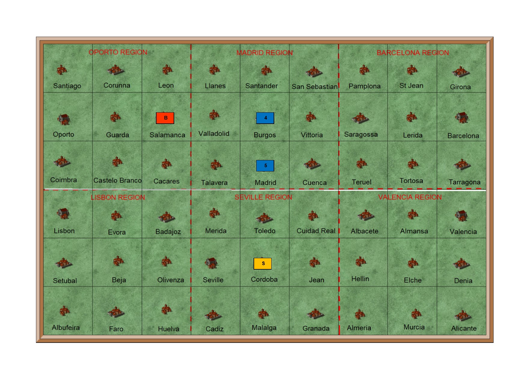
The new Spain would have six regions, as shown above.   Wellington would operate in the north, and Giron in the south.   This would mean that the centre regions, the active region in the campaign, would be Madrid to the north coast, and Madrid to the south coast.   This was the area most used in the previous campaign.

It does mean that the Lisbon region would be in the Spanish campaign area.   This was not ideal, but could not be avoided.   I would also have the option of spreading the Spanish area from Seville to Valencia

The northern campaign area was a better fit for Wellington.  It would include Oporto, an acceptable alternative main supply base.   The main campaign area would include the familiar names of Talavera, Burgos, Vittoria and San Sebastian.

Fortunately the French did not have a secure rear area in Spain.   Because neither Barcellona nor Valencia regions would fit that bill.   Instead they would operate from Madrid and Burgos.   And the critical city of Madrid was on the border between Wellington and Giron.

I am very pleased with this compromise.  But I do wish I had thought of it before I created all of the new campaign maps, many of which then had to be altered.

Wednesday, 15 July 2020

1813 Campaign – New Maps


New Map of France
France is not yet divided into campaign areas
This will be done if, and when, the campaign moves into France

France is dived into 8 military regions
Each military region has 9 districts
Each district has 9 towns

There are 729 towns in France
Each town is a wargames table
New Map of Italy
Italy is not yet divided into campaign areas
This will be done if, and when, the campaign moves into Italy

Italy is dived into 7 military regions
Each military region has 9 districts
Each district has 9 towns

There are 567 towns in Italy
Each town is a wargames table
New Map of Europe
Europe is dived into 32 military regions
Each military region has 9 districts
Each district has 9 towns

There are 2592 towns in Europe
Each town is a wargames table

Future Map Project
All of the new maps are basic in design.   The intention is to make the military regions and districts obvious and help me to remember them all.   These are ideal for running the campaign, but not really suitable for the campaign diary blog

Current maps look more like “proper” maps, even though they are not really accurate.   In the future I hope to combine the look of the old campaign maps with the detail of the new ones.

Wednesday, 8 July 2020

New 1813 Campaign Progress


Brunswick Region

We have managed a lot of test play on the new campaign, and it soon became clear that major adjustments were necessary.

I had planned that the area for each campaign would be one of the military regions.  Each region has nine districts, and each district would be a wargames table.   But it soon became obvious that this was too great an area to fit on a 6x6 foot wargames table.   For example from Hannover to Hamburg was one wargames table.   But in fact this is 150km.   Much too far even for a fictional campaign.

So I decided to make each district a campaign area.  But to do so I would have to divide the district into nine towns/villages.   And each one would be a wargames table.   The map above shows how this works for the Brunswick region.

Each square on this map is a wargames table and one days movement on the campaign map.   The distance from Hannover to Hamburg is three squares, which is three days march.   50km a day is still stretching it a little, but is easier to accept than
150 km a day.

Most of them are much shorter.  For example Hannover to Brunswick is 60km, a very reasonable 20km per day.

The second problem was the new supply system.

I had planned to limit each campaign phase by restricting each corps to seven days supplies, without the option of resupply.   This seemed reasonable in theory, but did not work in practice.   Each army had to spend time to establish a depot to bring forward their supplies, then wait to issue them.   It made any advance impossible to support.

So I have planned to revert to the previous system of supply.   Each corps will start with four days, plus one day in depot.   Each depot will collect one days supplies per day.   Each army will have a reserve corps of four infantry brigades to garrison depots.  So each army can have a maximum of four depots, one for each corps.

Just completed the reorganisation, and hope to test play the first campaign this week.


Sunday, 28 June 2020

1813 Campaign – New Maps


New Map of Germany
I had hoped to be able to fit the new military districts into the existing maps.
But this has not proved possible.   So I have had to make new maps.     

Germany is divided into three campaign areas
These are outlined in white

North Germany – 1st French v Prussian Army
Central Germany – 2nd French v Russian Army
South Germany – 3rd French v Austrian Army

Germany is divided into 9 military regions and 81 military districts.
The 9 regions are outlined in red
Each region has 9 districts
One square is a district, and also a wargames table
New Map of Spain
Spain is divided into two campaign areas
These are outlined in white

North Spain – 4th French army v Spanish Army
South Spain – 5th French army v Anglo-Portuguese Army

Spain is divided into 7 military regions and 63 military districts
Each square on this map is a military district, and also a wargames table
Each military region consists of 9 squares
Old Map of Europe

More Maps to Follow
Germany and Spain are the two most important maps, because that is where the current campaign is fought.  

I will also have to make a new map of Europe.   And before I can do that I will need to make one for France and Italy.    Now that I have worked out the best layout I am hoping that this will not take too long.   

However in the past the biggest problem has been trying to align France with Germany and Spain.  

Sunday, 21 June 2020

Campaign Map to Table


Campaign map of North Germany

This is the first attempt to run a campaign using the new maps, and to transfer a battle from the campaign map to the table.

This map is used for planning, and will be the one I use to introduce the new higher level of command to the campaign.

It covers the area of North Germany which will be used by 1st French Army and the Prussian Army.

Each square is a military district, and will also be a wargames table.   Nine squares (3x3) are a military region.

Arnhem region, on the left, is the staging area of the French Army, and contains their main depot at Arnhem

Berlin region, on the right, serves the same purpose for the Prussian army, and their main depot is at Berlin.

The Prussians have entered Hamburg region, in the centre, which will provoke a French reaction.   They have deployed one corps on the border as a covering force, and to give them warning of a French attack.   Their main strength is in the centre.   This is to enable them to react to any attack, but in particular one on Hamburg.

The French plan is to attack Brunswick (bottom left).   They have deployed one corps in each district along the border, to force the Prussians to do the same and to hide their intention.   3rd French, 4th French and 13th Polish corps will all cross the border at the same time.   Napoleon, with the 1st Old Guard corps, will support the Polish corps to take Brunswick.
Campaign map of Hamburg Region

This is the map which will be used for the campaign movement and diary.  It looks very similar to any of the existing campaign maps.  It is the same size and shows very similar terrain.  It also uses the same sized corps symbols.

The Prussian deployment is the same as on the map of North Germany.   3rd, 4th and 13th French corps are shown just off map and will enter at the start of the campaign.   Napoleon and the Old Guard corps are behind 13th corps.
Wargames map of Hamburg Region

This is the map which is used to transfer the terrain from the campaign map to the wargames table.  It is exactly the same as maps I currently use.   Each square is the same as in the Campaign Map of the Hamburg Region, but it shows more clearly what each 2x2 foot scenic square will look like on the table.  In the top right of each square is a number.   This is the number of the scenic square which will be used to make up the wargames table.

So far all looks quite good.  I think the maps will work, but only play testing will determine the truth.

However I now have a further task.   In the current campaign all of this map would be used to fight the campaign phase.   This was because it covered such a smaller area.  However in this campaign I will have to devise a way of restricting the contest to just the Brunswick area.   Or at least determine the outcome of the campaign phase to the capture of the Brunswick area.  

This will be done by limiting the amount of time both armies have to determine the winner.   At present I am working on limited supply for each army, so that they have perhaps 7 days to take and hold the objective, in this case Brunswick.

This first campaign will quickly determine whether all of this works in practice or not.