Sunday 31 January 2021

Valladolid Campaign – Day 1


23 March 1813 – Northern Spain – Day 1

Both armies advance with orders to make contact with the enemy, but avoid a battle

The Centre and north wing both halt as soon as they sight the enemy

Wellington orders the southern wing to probe the town of Arevalo

Soult orders his southern wing to react to the enemy

Battle of Arevalo – move 2

Both armies advance towards the town of Arevalo

Neither commander want to engage in a major battle


The eastern half of the town is held by 6th Spanish brigade

The British commander is determined to support them


The French will reach the Spanish held part of the town first

The French commander takes command of two brigades from 7th corps

With them he will attack and take the town

7th and 13th corps are ordered to hold the north and south of the town


French artillery rout the Spanish garrison

The British commander takes command of one brigade from each corps

He leads them into the town to prevent its capture by the French


The battle is decided by the fight for the town.

Artillery on both sides support the attack, but have little effect


At nightfall the French hold the town and win the battle

Town Fighting

The ground area of all built up areas is defined by 6x6” squares of felt.  One square represents a village or farm, two squares a small town and four squares a city.   Arevalo is one of three walled towns in this campaign.


Only infantry can fight in built up areas, they move 4” per turn which is half speed.   As soon as they enter the town the buildings are removed to allow skirmish and hand to hand fighting, plus exact location of each brigade.


Two brigades are allowed in each town section.   Only one can fight, the second is a reserve.   If the support it within 2” they can replace the forward brigade.   It takes a full move and both are disorganised during that move.


When a brigade reaches the forward edge of the felt square they have two options.   They can become a garrison, which takes a full move.    They then have advantage of cover and have an advantage is skirmish and hand to hand fighting.   Fighting for a defended town section often ends in victory for the defender, unless the attacker can attack with at least one more brigade outside the town.

Or the brigade can advance to engage in hand to hand fighting.   When the two brigades are within 4” the one who moves first next move can charge and gain plus one on the first melee for impetus.   This hand to hand fighting always results in casualties and usually does not last more than one or two moves.


In this game the town fighting went on five moves.   At the end of the first move the British lost and routed.   The reserve brigade moved forward to replace them.   The French reserve took advantage of this lull to do the same.   The two reserve brigades then fought for four moves, each taking casualties each move.    Finally the British routed with 30% casualties and the French stood with 20% casualties.


During the fighting for the town the Spanish lost 1 casualty, the British 5 and the French also 5.   One French casualty was caused by artillery fire.


The rest of both armies just stood and watched.   Both had orders to observe, and not to engage in a major battle.   Both probably exceed their orders to risk so much in town fighting.


Very interesting game for town fighting, but did not put the larger 6 corps armies to the test.

Sunday 24 January 2021

Valladolid Campaign


Map of Spain 

The next campaign phase is set in Northern Spain.   This is the fourth phase of the Sixth 1813 campaign, it is also the second phase set in Spain.


This campaign will be between the Anglo-Portuguese Army commanded by Wellington and the Fifth French Army commanded by Soult.  

Regions of Spain

This campaign takes place in the Madrid Region.   Valladolid is one of nine districts in this region.   Both armies are tasked to take and hold the city of Valladolid.

Valladolid District

 This map shows the location of both armies at the start of the campaign.  

Red are British, Blue French and Yellow Spanish.   There are nine towns and each one is a wargames table.

 This is the first campaign phase to feature the new six corps per side.   Each army has deployed as a centre and two wings, each of two corps.   The centre is commanded by the CinC (Wellington or Soult).   Each wing is commanded by a senior general.

The three commands have as their campaign objective one of the three towns in the centre of the map.   All three come under the command of the CinC, and he can order any corps to move between commands.   However his initial command is to advance and take the town in the centre.

 Each town has an independent Spanish brigade as a garrison.  When the town is taken by the French, the garrison become a guerrilla band.

 It was difficult to balance the two armies.   The French and British each have six corps, each of one cavalry and four infantry brigades plus corps artillery.   In addition the British have nine Spanish brigades as town garrisons or guerrilla.   They do not come under the command of Wellington, but will fight against the French.   To even the odds I have given Soult four independent infantry brigades to act as town garrisons.   If he wants he can attach them to one of his corps, or to his own headquarters.

It will be interesting to see how the new six corps army works compared with previous four corps army.

Sunday 17 January 2021

1813 Campaign Blog


For the past few months I have been working on updating the campaign blog.   This was the unintended consequence of introducing military regions. 

I started the blog in April 2009 to record the fictional 1813 campaign.   This was my first attempt to keep a blog, and it has been a constantly changing learning experience.  

I never intended that the blog, or the campaign, should last more than a few months.   It started as a solo campaign, and I planned it to be similar in length to the Waterloo campaign.  I expected that it would provide half a dozen battles to wargame, and that would be the end.

In July 2009 I converted it to a PBEM campaign.   The blog became a major part of the campaign, as it provided the other players with a narrative of the campaign complete with maps, photographs and battle reports.    It also required a new blog.  

From the start I used the blog labels as an index of the blog.   But I thought that I would have to start a new blog for each campaign phase.   It was not until early 2015 that I realised I could keep the same blog going, and also use the labels as an index.  That was when the current blog started, and there have been 681 posts since then.

The index consists of 29 labels

1 introduction to the whole campaign

2 campaign areas

3 introduction to the campaign in Germany

4 introduction to the campaign in Spain

11 to 15 diary of campaign in north Germany

21 to 25 diary of campaign in central Germany

31 to 35 diary of campaign in southern Germany

41 to 45 diary of campaign in north Spain

51 to 55 diary of campaign in southern Spain

You will note that gaps have been left in the numbers to insert new labels should it be necessary.

All of this has evolved over many years, and I had not realised just how much information was contained in the blog.   And worse still how much would have to be updated due to the introduction of military regions.

I have never tried to amend or update the 25 labels from 11 to 55, recording the 42 independent campaign phases.   The campaign has changed greatly, but the changes have not been recorded until the next campaign phase.

But the introduction of military regions has changed the whole structure of the campaign.  Not only all of the maps, but also the narrative and objectives of each campaign phase.

So it has been necessary to change labels 1 to 4 entirely.   And also to replace the introduction to each of the five campaign areas.   This has been a major job, and has taken about four months.

All of them have now been replaced and at last the campaign diary reflects the actual campaign again.

If you would like to find out more about the campaign you will find the blog here

http://1813pbemcampaigndiary.blogspot.com.es/        

Sunday 10 January 2021

Unintended Consequences


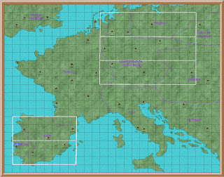
Standard map of Europe showing regional capitols and campaign areas

Like so many others, I had a lot of time on my hands last year

When this happens I usually review my 1813 campaign, and see how I could improve it.   Most often this exercise results in minor, or no, amendments.   The campaign has run non stop since April 2009.  It has of course changed since then, mostly in the maps I use.

Starting with hand drawn maps, I soon discovered Profantasy maps.   This is a computer based system for creating maps.  It transformed my poor maps into something very practical, if not very pretty.   I am not artistic, as was very obvious from my first hand drawn maps. But with Profantasy I could at least produce neat maps.

I needed maps to cover all of Europe, but in particular Germany, Portugal and Spain.   I needed national maps for strategic movement, and very detailed maps to transfer from the campaign map to the wargames table.

I quickly found that it was difficult, if not impossible, to find the type of maps I wanted online.   I did have quite a few useful maps in my library.   The most important of which was the West Point Military History and Atlas of the Napoleonic Wars.   This was very useful for detailed maps of battlefields, and also for grand strategy maps.   But the terrain details and borders of the smaller countries, particularly the Confederation of the Rhine, was difficult to obtain.

I could manage a reasonable series of maps with cities, towns and even villages in relation to each other.   Major rivers were not too much trouble.   But mountain ranges, medium rivers, and forests were the problem.

Making the smaller campaign maps, about the size of the Waterloo campaign, was not difficult.   But putting them together to form a map of Germany, let along Europe, was another matter.

I compromised for many years, but this year I decided to find a solution. 

Regional Map of Europe showing districts and campaign areas

I found the solution in a system of regions and districts.    The whole of Europe would be divided into 33 regions, each region would have nine districts.   Each district would have nine towns, which were also wargame tables.

Each region was named after a major city.   National borders were ignored, for example Lisbon region included Badajoz, which is in Spain.   This was done because any campaign aimed at taking Lisbon would use Badajoz as a base for the French invaders.

Each of the five campaign areas have three regions

In Germany the left hand one is the French reserve area

The right hand is the Allied reserve area

The centre region is where the campaign will be fought

There are nine districts and each one will be a campaign phase

What I had not anticipated just how much work all of this would require.   Making the campaign maps (see photo 2) was relatively easy.    But that then had to be transferred to a scenic map for each region and district.   And that was only the start of my problems.

Since the start of the 1813 campaign I have kept a blog which is a diary of the whole campaign.   This has grown up over the years, and is now quite a complicated document.

I soon realised that I would have to redo a lot of the background information

This was not only to replace the old maps

But also to explain the new regional concept 

Just as I completed all of the above I decided that I wanted to replace the old four corps army system with six corps.   But that is a project for 2021.