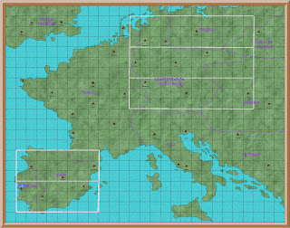
Standard map of Europe showing regional capitols and campaign areas
Like so many others, I had a lot of time on my hands last year
When this happens I usually review my 1813 campaign, and see how I could improve it. Most often this exercise results in minor, or no, amendments. The campaign has run non stop since April 2009. It has of course changed since then, mostly in the maps I use.
Starting with hand drawn maps, I soon discovered Profantasy maps. This is a computer based system for creating maps. It transformed my poor maps into something very practical, if not very pretty. I am not artistic, as was very obvious from my first hand drawn maps. But with Profantasy I could at least produce neat maps.
I needed maps to cover all of Europe, but in particular Germany, Portugal and Spain. I needed national maps for strategic movement, and very detailed maps to transfer from the campaign map to the wargames table.
I quickly found that it was difficult, if not impossible, to find the type of maps I wanted online. I did have quite a few useful maps in my library. The most important of which was the West Point Military History and Atlas of the Napoleonic Wars. This was very useful for detailed maps of battlefields, and also for grand strategy maps. But the terrain details and borders of the smaller countries, particularly the Confederation of the Rhine, was difficult to obtain.
I could manage a reasonable series of maps with cities, towns and even villages in relation to each other. Major rivers were not too much trouble. But mountain ranges, medium rivers, and forests were the problem.
Making the smaller campaign maps, about the size of the Waterloo campaign, was not difficult. But putting them together to form a map of Germany, let along Europe, was another matter.
I compromised for many years, but this year I decided to find a solution.
I found the solution in a system of regions and districts. The whole of Europe would be divided into 33 regions, each region would have nine districts. Each district would have nine towns, which were also wargame tables.
Each region was named after a major city. National borders were ignored, for example Lisbon region included Badajoz, which is in Spain. This was done because any campaign aimed at taking Lisbon would use Badajoz as a base for the French invaders.
Each of the five campaign areas have three regions
In Germany the left hand one is the French reserve area
The right hand is the Allied reserve area
The centre region is where the campaign will be fought
There are nine districts and each one will be a campaign phase
What I had not anticipated just how much work all of this would require. Making the campaign maps (see photo 2) was relatively easy. But that then had to be transferred to a scenic map for each region and district. And that was only the start of my problems.
Since the start of the 1813 campaign I have kept a blog which is a diary of the whole campaign. This has grown up over the years, and is now quite a complicated document.
I soon realised that I would have to redo a lot of the
background information
This was not only to replace the old maps
But also to explain the new regional concept
Just as I completed all of the above I decided that I wanted to replace the old four corps army system with six corps. But that is a project for 2021.


Work, work, work! But all in a good cause.
ReplyDeleteHave you ever tried exploring google maps. With the satellite option you can get aerial photographs of almost anywhere with the capability to zoom out for an overview of an area or zoom in for detail. (Close enough that I was able to zoom in on our house and identify roughly when the picture was taken by the cars in our driveway. For locations of public interest there is often the option to look at ground level photos and panoramas. ( ie Waterloo etc) New tech for those of us of a certain age but a very useful tool or distraction.
Hi Ross
ReplyDeleteI did use google maps, which I found very good for locations and distances. Less good for rivers and less still for mountains major terrain.
It may well be me, but I have found it difficult to move from local maps to area, regional and national. Creating the map with towns and even villages is quite easy. But, for example, imposing the Harz mountains on that map proved to be beyond my skills.
It may well be that my interest in maps is very limited. I know what I want, but perhaps do not have sufficient patience to learn the skills to find it on google map.
I have had to compromise so much with the locations of towns and villages, that the major rivers and terrain features are only approximate.
But I am pleased with the end result - at least for now
regards
Paul
Interesting to read about the thinking behind your maps and various mapping challenges.
ReplyDeleteHi Peter
ReplyDeleteGetting the maps right has been the most difficult part of the whole campaign.
The tactical map is really just a series of wargames tables, as it has to be to transfer from the map to the table and back again.
Each one covers an area about the size of the Waterloo campaign. But trying to then create a map of Belgium, let alone Germany or Spain, using the same detail and making an end result that still looks like an actual map, was really difficult.
My new regional maps are less like an actual map, but they do solve the problem of upscaling the tactical maps.
regards
Paul