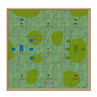
Regions of Germany
The
next campaign is set in central Germany.
This
is the second campaign phase of the new campaign
It
shows that the French have occupied Brunswick at the end of the last phase
There
are nine regions in Germany, and three in central Germany.
This
phase is fought in Erfurt, the central of the three
This
map is used for planning and shows the location of each army
Each
square on this map is three wargames tables.
Erfurt Region
This
map shows the main geographical features of the region, and also the location
both armies and their supply depots.
There
are nine towns on the map. Each is a
military district. Each is also a
possible campaign phase.
The
Erfurt campaign phase is the nine squares in the centre, with the white star in
the centre.
Each square on this map is also one wargames table
Erfurt District
Campaign Map
This
is the campaign map, used for movement and transferring to the wargames
table. This map shows considerably more terrain
features, such as villages and farms. I
use this map for the campaign movement.
Each square on this map is a 2x2 foot square on the wargames table
Erfurt District Wargame
Map
This
map shows the same details as the previous one, but shows the actual terrain as
it will appear on the wargames table.
For example the hills cover the same area, but are shows as they will
look on the table.
Each
square is numbered the same as the 2x2 foot scenic terrain. Villages and farms are also numbered to
identify the wargame models. Where
appropriate hedges and stone walls are also noted.
You
will note that the strategic campaign planning maps, such as Regions of
Germany, are in the new grid system. The
aim is to make it easier to identify the new military regions and
districts. Terrain features are not
important at this level of planning.
These maps are used to decide where the next campaign phase will be
fought.
The
rest of the maps are more traditional.
They shows different levels of terrain features, because they are very
important in the campaign and on the table.
The last map is designed to show exactly what the wargames table will
look like.
With our summer routine we spend a lot more time on the campaign and the wargames table. With the cooler weather we resume our two hill walking groups, and we have much less time for wargaming.


No comments:
Post a Comment
I have set the settings for comments to come to me before posting so that I will not miss any