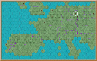
First Map of Europe
It
gets pretty hot in the summer months here in the Valencian province of
Spain. Each year we have a project to
keep us occupied during the hottest part of the day. For many years it was making model buildings
for our campaign. We completed the last
of that project last year. This year I
decided to make a new set of campaign maps.
When
I started making campaign maps I was only interested in the area covered by my
proposed campaign. This was the 1813
Napoleonic campaign, so I made maps for Germany and Spain. There were five campaign areas, three in
Germany and two in Spain. I wanted to be
able to show the whole campaign area, but found it very difficult to show even
major cities on a map of all Europe.
For many years I published two maps to do so, one of Germany and one of
Spain.
Last
year I completed my first attempt at a map of all Europe. It is shown above.
Each
square on the map is a major city. It
is not to scale with the maps of Germany and Spain. The location of each city is roughly
correct. But I was not pleased with the
result. I am not very artistic, and it
does not look much like a real map. In
addition because it does not interface with the existing maps of Germany and
Spain it is not very useful for the campaign.
For
reference the square outlined in white is Berlin.
AA Road Atlas
When
I started making campaign maps I used an AA Road Atlas of Europe as the
template. It already had a grid where
each square was 15 miles. This became my
daily move rate for the campaign. It
would also be the area covered by my wargames table. All
I had to do then was copy the information from the Road Atlas onto my campaign
map, using the same square grid.
This
is a page from the Road Atlas. It shows
northern Germany, including Berlin. The
original grid is 8 wide by 10 deep.
However I have drawn a second grid, with each square 4x4 of the original
grid. This gives an area of 60x60
miles. Each grid will be a campaign phase
area, and will interface with the German and Spanish maps.
Again
for reference the square outlined in black includes Berlin.
New Map of Europe
I
now produced my new map of Europe. I
made the first one with squares, so that I could compare then with the existing
campaign maps of Germany and Spain. I
then made a second map with a hex grid.
In this scale the only information shown is the location of each city
and town. Only major cities have
buildings, but all squares have the names of the major town on each. I also show major national boundaries, but
not terrain, rivers or roads. That will
be shown on the more detailed maps of Germany, France, Spain and Italy.
Once
more for reference the hex outlined in white is Berlin.
I
am pleased with this map. Because it is
hex it does not rely on my map making skills to make it look reasonable. Because each square is 4x4 on my existing
maps it makes campaign strategic planning much easier. Because so little detail is shown I did not
have to make very complicated maps of France and Italy.
At
first I had intended to continue to use my existing maps of Germany and
Spain. But because they are factual they
contain a lot of modern detail, I have now decided to make a new set of maps
which will be fictional. They will
show cities and towns in approximately the correct location. However national borders will be only roughly
correct, as will major rivers. The road
system will be fictional. Major roads will
connect major cities, minor roads connect towns. Hills will be completely fictional, and will
just provide movement barriers.
Next
week I will deal with the national map of Germany.


Thanks for the post.
ReplyDeleteI always tried to imagine what your office would be like. I suspected you had a wonderful map board full of counters and arrows !
Hi Jacko
ReplyDeleteWhen I started the campaign I did indeed have paper maps and hand written notes. But now everything is on the computer. Its so much easier to amend and keep up to date. But I make sure that I back up my work each day. I have never actually lost anything, but if I did it would be very difficult to replace.