
Germany Stage One
In
August I wrote a blog about my summer project of making new campaign maps. I am pleased to confirm that I have finished
the first one. I call it Germany, but
it also includes Poland and Austria. It
covers the whole area over which the Prussian, Russian and Austrian armies will
campaign.
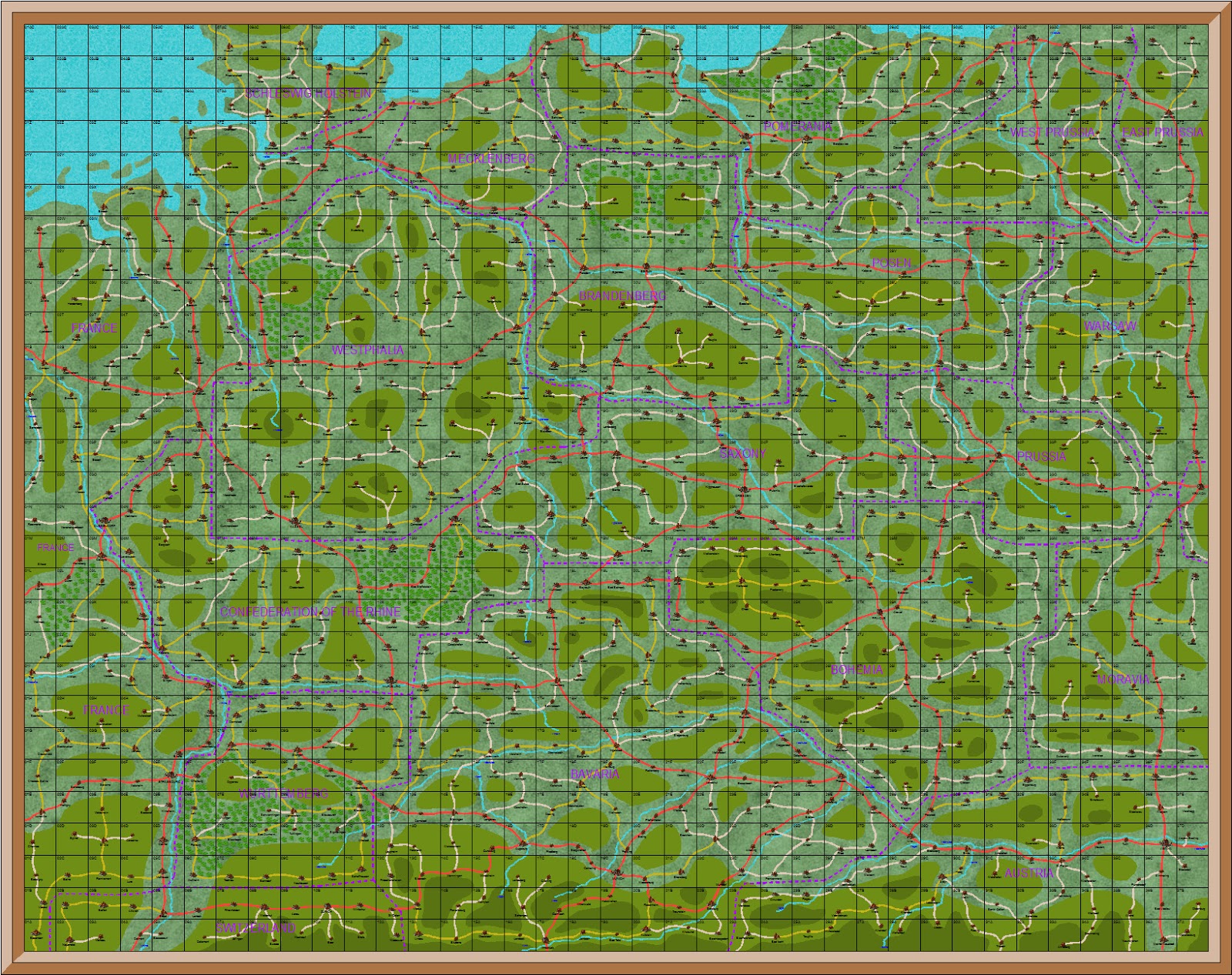
The
map has a grid which is 37 squares wide by 29 squares deep. This gives a total of 1073 squares. There
are 41 squares with sea, leaving 1032 land squares. Each land square has the name of a city or
town. Each square is 20 miles. For the purpose of the campaign each square
is a battle area or the size of a wargames table. So there are a possible 1032 named battle
areas.
Stage
One of the map shows major terrain features.
Major rivers, major mountains and forests are shown. For the first time national borders are also
shown, as are the capitals of each country.

Germany Stage Two
Major
roads have been added in this map. They
are coloured red and connect the capital city of each country. They are the only roads which cross national
borders.
Germany Stage Three
This
is the completed map. All towns and
cities have been added. Within each
country cities not already joined by a red road and now connected by a yellow
road. Any towns not already connected
by a red or yellow road and now connected by a light brown one. These three coloured roads are for strategic
purposes only. Red are international
roads connecting capital cities. Yellow
are major national roads connecting cities within each country. Brown are minor roads connecting towns
within each country.
This
road grading is for strategic purposes only.
It indicates main movement and supply roads on an international and
national basis. For campaign movement
all three types of road are the same.
Corps move three squares per day on roads, two squares off road on good
terrain and one square per day on difficult terrain. Mountains, rivers and woods are difficult
terrain.
Campaign
strategic maps for all phases set in Germany will be taken from this map. I will have to make a similar map for Spain
to cover the campaign in the Iberian Peninsula.
Your map looks great.
ReplyDeleteHave fun with the upcoming campaign!
They look great and easy to use
ReplyDeleteWimVdB
ReplyDeletethanks for your comments. It was difficult to get the map right, and I kept changing it when I saw the finished product. But it became very addictive and I am quite looking forward to the one of Portugal and Spain
regards
Paul
Jacko
ReplyDeleteThanks for your comment
The maps are very easy to use, though I had to make an extract for each of the campaign areas. The full map of Germany was just too big to work on for the campaign.
regards
Paul
ReplyDelete