Campaign Maps of Northern Europe
I have completed the four campaign maps for northern Europe .
All of these maps are best used on the computer, as it is possible to “zoom in” for the extra detail. However I want to be able to print them on A4 paper to use as hard copy maps.
To print them on A4 paper I have to make a JPEG copy of each completed map. It is not possible to “zoom in” on a JPEG copy. So you will not be able to see the full details of these maps on the computer. But it will give you an idea of what they look like.
 Northern Europe
I have outlined the area of each campaign map on this map of northern Europe to show how they overlap. North, Central and South West can be joined to make one map from the north coast down to the Alps . However the South West map does not go far enough east to include Vienna , and would not be suitable for the Danube campaign. So I have added a South East map which covers this particular area.
 North
North
The North covers an area from the Munster to Berlin , and in particular the corridor from Hannover through Magdeburg to Berlin Leipzig
 Centre
The Centre covers the area from Dusseldorf to Dresden Magdeburg Jena
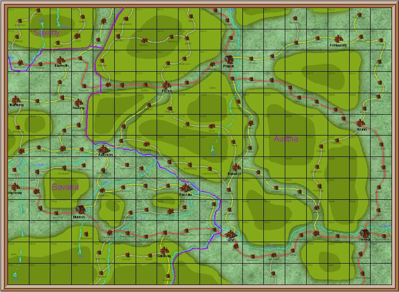 South East
The South East covers the aqrea from Munich to Vienna and north to Prague. It overlaps with the South West and part of the Centre. It covers the historical 1805 Ulm campaign area and also the 1809 Aspern-Wagram area.

The South West covers the area from Strasbourg to Munich. It overlaps with the Centre map to complete the area from the north coast to the Alps. It also overlaps with the South East map to complete the Danube valley area.
The maps have been very easy to make, though more time consuming that I had anticipated. ProFantasy is not an easy programme to master, and involves quite a steep learning curve. However I would not consider myself a competent computer user, and if I can manage to learn it I would think that anyone can. Providing that they are prepared to stick with it.
The next step will be to make the campaign maps for Spain. I have already done much of the ground work and expect to finish them quite quickly.
If you would like to make your own campaign maps, or indeed any other maps, I would strongly recommend ProFantasy. It is relatively cheap to buy, and I have found the forum to be a place where help and advice is provided in simple language which even I can understand.


