Strategic Campaign
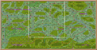
Map of Germany
The
campaign map of Germany is 37 squares wide by 29 squares deep. Each square is a battlefield or wargames
table. This map is too large to use on
the campaign diary blog, it is also too large for detailed work. So I make a smaller map for each of the five
campaign areas.
The
white box on the map is the area used for the campaign in Southern
Germany. It is 24 squares wide by 12
deep.
Strategic Campaign Map of
Southern Germany
This
map covers the area from Prague to Koblenz, and Linz to Basel. This is the area of operations for the
Bavarian/Baden Army and the Austrian Army.
The white box on the map is the area of the next campaign phase in
Southern Germany, which is the Erlangen Phase.
The area of 9 x 9 squares.
Strategic Campaign Map
for Erlangen Phase
This
is the strategic map for the Erlangen campaign phase. It covers the area from Bayreuth, which is
the Austrian main supply depot, to Wurzburg, which is the main supply depot for
the Bavarian/Baden Army.
The
white box on the map is the area for the tactical map for the Erlangen
phase. You will note that the town of Erlangen is in
the middle of the nine squares.
On
this map you can see that there are different types of cities or towns. The capital cities, such as Wurzburg, have a
cathedral. They may be either open or
walled. Other cities, such as Bamberg
or Nuremberg, are indicated by a cluster of buildings. Again they can be open or walled. All other towns are indicated by a group of
two buildings. Any city or town
adjacent to a national border are walled.
All other cities or towns are open, unless they are known to be walled,
such as Augsburg.
Maps
have to be quite small to be able to read on the Campaign Diary Blog. If I did not record the campaign on the blog
I could make do with the large map of Germany.
Although it is impossible to read the detail on the blog, it is easy to
enlarge it to work on the computer.
Next
time I will explain the tactical maps, which are used to provide the actual wargame
table.


